29th August 2010
I’ve been asking myself ever since I came up with the idea of riding to Edinburgh, how the hell am I going to navigate there? So today was all about that question.
Sustrans are the charity that created the NCN (National Cycling network), you can find more information here http://en.wikipedia.org/wiki/National_Cycle_Network. There are routes that span the whole of the UK that are numbered and, unless someone with an asbo has ridden past on a stolen bike, sign posted. There are major routes for example Route 1 goes all the way from Dover to London and then up the east coast of the country to Edinburgh and on to John o'Groats. They also sell maps that make up certain sections of the country so you’ll need to by one or more depending on how far you’re planning to ride. I ordered myself two maps that covered the last third of the journey from Oxford to Edinburgh http://www.sustransshop.org.uk/products/5045-ncn-coast--castles-south & http://www.sustransshop.org.uk/products/5044-ncn-three-rivers
The maps, it has to be said, could do with a little if not a lot more detail. The way I plan to navigate the trip is to use a physical map, plot the way points within some mapping software like Google Earth before loading the routes into the GPS. So it’s really important to be able to identify a road on the physical map and match that with the software map, and to be honest the detail is such that there is a lot of interpretation going on.
The NCN is also shown on http://www.bikehike.co.uk/mapview.php which almost eliminates the need for a real map.
There is also the separate problem of getting the GPS file in the correct format. For example Google Earth uses a .kml extension while the Garmin GPS supports .tcx and gpx file, then within .gpx there are two type - Route and Track. My preferred method now is to route within Google Earth, because you have all the interaction advantages of a desktop application, then upload the .kml to http://www.bikehike.co.uk/mapview.php and then download it as a .gpx track, effectively using bikehike.co.uk as a file converter.
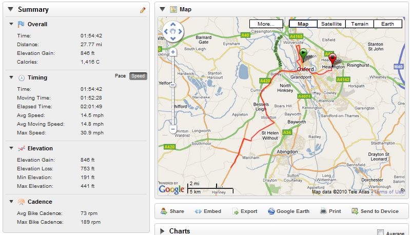
So after all that I mapped myself a short route around the block to get used to what prompts the GPS will give a each way point.
There is an inbuilt compass which always points in the direction, North, South, East or West, you’re heading. In other words it’s not sensitive to your movements. As far as notification goes the device switches to a screen displaying a picture of the junction you are expected to turn at appoximatily 200 meters from the turn, whether you are heading right or left and some appropriate arrow. You also get a count down in feet or meters depending on how you like to think of your distances.
This is all pretty cool, just have to get on the bike tomorrow and let it take me somewhere, see what happens.
I’ve been asking myself ever since I came up with the idea of riding to Edinburgh, how the hell am I going to navigate there? So today was all about that question.
Sustrans are the charity that created the NCN (National Cycling network), you can find more information here http://en.wikipedia.org/wiki/National_Cycle_Network. There are routes that span the whole of the UK that are numbered and, unless someone with an asbo has ridden past on a stolen bike, sign posted. There are major routes for example Route 1 goes all the way from Dover to London and then up the east coast of the country to Edinburgh and on to John o'Groats. They also sell maps that make up certain sections of the country so you’ll need to by one or more depending on how far you’re planning to ride. I ordered myself two maps that covered the last third of the journey from Oxford to Edinburgh http://www.sustransshop.org.uk/products/5045-ncn-coast--castles-south & http://www.sustransshop.org.uk/products/5044-ncn-three-rivers
The maps, it has to be said, could do with a little if not a lot more detail. The way I plan to navigate the trip is to use a physical map, plot the way points within some mapping software like Google Earth before loading the routes into the GPS. So it’s really important to be able to identify a road on the physical map and match that with the software map, and to be honest the detail is such that there is a lot of interpretation going on.
The NCN is also shown on http://www.bikehike.co.uk/mapview.php which almost eliminates the need for a real map.
There is also the separate problem of getting the GPS file in the correct format. For example Google Earth uses a .kml extension while the Garmin GPS supports .tcx and gpx file, then within .gpx there are two type - Route and Track. My preferred method now is to route within Google Earth, because you have all the interaction advantages of a desktop application, then upload the .kml to http://www.bikehike.co.uk/mapview.php and then download it as a .gpx track, effectively using bikehike.co.uk as a file converter.
So after all that I mapped myself a short route around the block to get used to what prompts the GPS will give a each way point.
There is an inbuilt compass which always points in the direction, North, South, East or West, you’re heading. In other words it’s not sensitive to your movements. As far as notification goes the device switches to a screen displaying a picture of the junction you are expected to turn at appoximatily 200 meters from the turn, whether you are heading right or left and some appropriate arrow. You also get a count down in feet or meters depending on how you like to think of your distances.
This is all pretty cool, just have to get on the bike tomorrow and let it take me somewhere, see what happens.