Okay, so here’s the first bit of data coming out of the Edward training labs using the Garmin 705 GPS. The device gives information such as Cadence, Heart rate, speed etc... but it also has maps which work which like a sat nav, bit harder to use than a sat nav but you get the idea. After installing eight software packages it was finally time to go out for a ride.
I'm viewing all the data with Gamin training centre, here's some screen shots
Elevation measured by the on board altimeter – Quite surprised there was a 50m change in this, just shows Headington really is on a hill.
Grade % which = elevation/distance * 100 which can be thought of as incline.
Pace which is an inverse of speed which measures at any point in time how long it takes to travel a unit of distance (km in this case),
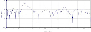
Finally speed, reached 45km/h at one point, which is about as fast my brain will let me go in the rain.
I mapped the route out using http://www.bikehike.co.uk/mapview.php , the download it as a .GPX file straight onto the GPS. Google Earth is also becoming pretty useful.


No comments:
Post a Comment